
Station Report
Geoid velocity added
To correct for the vertical drift between reference frames, the velocity of the geoid height (VN) is now calculated and incorporated into the calculation of the orthometric height. View documentation to learn more.
Site Identification
| Name | Province | NTS map sheet | Unique Number | Provincial Identifier | Network |
|---|---|---|---|---|---|
| PRDS CACS-GSD | Alberta | 082J16 | 756047 | 429225 | CSRS |
Station Coordinates
Changing these fields will auto-update the station coordinate information below.
The velocities are interpolated from the national Velocity Grid version 8.0.
| Latitude | |
|---|---|
| Longitude | |
| h (metres) | |
| Vφ (mm/y) | |
| Vλ (mm/y) | |
| Vh (mm/y) | |
| X (metres) | |
| Y (metres) | |
| Z (metres) | |
| Vx (mm/y) | |
| Vy (mm/y) | |
| Vz (mm/y) | |
| Zone | |
| Easting (metres) | |
| Northing (metres) | |
| h (metres) | |
| Scale | |
| Combined | |
| Convergence | |
| N (metres) | |
| H (metres) | |
| Published date Project ID | 2024-11-21 M24-002 |
| VN (mm/year) | |
| VH (mm/year) | |
| Equipot. of geoid model (W0, m2s-2) |
Vertical Data (levelling)
| Vertical Datum | Elevation (m) | Order | Gravity (mGal) | Published | Project ID |
|---|---|---|---|---|---|
| CGVD2013 (2010.0) | 1263.923 | 1st | 980750.22 | 2013 | H13ML1311 |
| CGVD28 | 1263.753 | 1st | 981140.93 | 1995 | N5A95 |
The CGVD2013 height reported in the Vertical Data table is approximate because it is calculated from historical levelling data and not from the combination of GNSS and a geoid model.
Vertical Datum Separation
| Datum 1 − Datum 2 | Elevation 1 (m) | Elevation 2 (m) | Elevation Difference (m) | Epoch |
|---|
Location
PRDS is a continuously tracking GNSS station and is part of the Canadian Active Control System (CACS). The station is co-located with the PRD2 and PRD3 GNSS stations near the Rothney Astrophysical Observatory in the rural community of Priddis, 7 km west of Calgary, Alberta.
The GNSS reference mark consists of a brass plate with a forced centered stainless steel bolt embedded on top of a 0.40 m in diameter concrete pier, extending into soil to a depth of 3.0 m and protruding 2.0 m above ground level.
Equipment on site
| Model/Type | Start date | |
|---|---|---|
| Receiver | JAVAD TRE_3N DELTA | 2019-11-12 18:42:00 |
| Clock | Internal | 2024-05-15 03:29:42 |
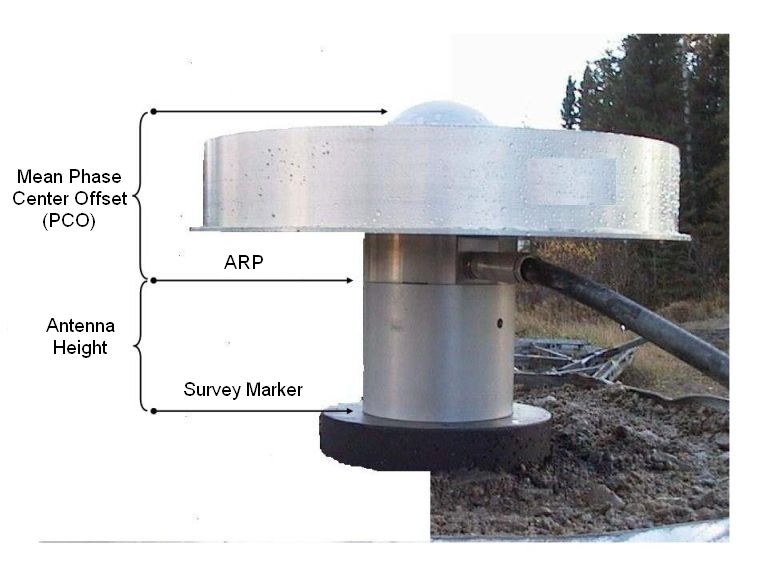
Antenna
| Model | Start date | Height (m) | Phase center offset (mm) | |||
|---|---|---|---|---|---|---|
| GPS L1 | GPS L2 | GLONASS L1 | GLONASS L2 | |||
| AOAD/M_T NONE | 2022-08-16 23:14:00 | 0.100 | 91.84 | 120.35 | 91.84 | 120.35 |
| AOAD/M_T NONE | 2012-07-27 20:00:00 | 0.100 | 91.84 | 120.35 | 91.84 | 120.35 |
| AOAD/M_T NONE | 2006-07-18 18:35:00 | 0.100 | 91.84 | 120.35 | 91.84 | 120.35 |
| AOAD/M_T NONE | 2003-05-21 00:00:00 | 0.100 | 91.84 | 120.35 | 91.84 | 120.35 |
| AOAD/M_T NONE | 2002-11-01 00:00:00 | 0.100 | 91.84 | 120.35 | 91.84 | 120.35 |
| AOAD/M_T NONE | 1999-06-14 14:40:00 | 0.100 | 91.84 | 120.35 | 91.84 | 120.35 |
| AOAD/M_T NONE | 1999-05-11 16:10:00 | 0.159 | 91.84 | 120.35 | 91.84 | 120.35 |
| AOAD/M_T NONE | 1997-01-07 00:00:00 | 0.100 | 91.84 | 120.35 | 91.84 | 120.35 |


Use of Canadian Geodetic Survey products and data is subject to the Open Government Licence - Canada
- Date modified: