
NAD83(CSRS) Updates
The Canadian Geodetic Survey (CGS) is releasing a new version of NAD83(CSRS) that is based on a transformation from ITRF2020. This new version improves the accuracy of NAD83(CSRS) and maintains its relationship with the ITRF. The transformation was derived from the procedure agreed upon with the U.S. National Geodetic Survey by adding the incremental ITRF2014‑ITRF2020 transformation, as adopted by the International Earth Rotation and Reference Frames Service, to the previously adopted ITRF2014‑NAD83(CSRS) v7 transformation. This transformation has been implemented in CGS tools CSRS-PPP, TRX, and GPS·H since the International GNSS Service adopted ITRF2020 (referred to as IGS20) in their operations.
This updated version of NAD83(CSRS) v8 is compatible with all previous versions of NAD83(CSRS) and uses the same 2010.0 coordinate reference epoch as NAD83(CSRS) v7. It provides a more accurate realization of NAD83(CSRS) for both coordinates and velocities of CACS and CBN stations, due to:
- six more years of observations at stations already in NAD83(CSRS) v7;
- new stations filling gaps in coverage, especially in northern and remote regions;
- reprocessing of data from public active control stations with IGS repro3 products, processing standards and models using the new Bernese v5.4 GNSS software;
- updated treatment of earthquakes and other transient velocity disruptions.
The coordinate differences with NAD83(CSRS) v7 at epoch 2010.0 are generally less than 1 cm while the velocity differences are of the order of 0.5-1 mm/yr. Differences between the versions of NAD83(CSRS) are mainly due to the effects of earthquakes, the amount of data used, changes to the adjustment and processing methodologies, and changes in the realization of ITRF2020.
Along with the new realization of NAD83(CSRS), CGS is releasing a new velocity grid which accounts for crustal motion in 3D. The new grid is implemented in the CGS tools CSRS-PPP and TRX for epoch transformations and is made available for scientific purposes such as relative sea level rise estimation.
Why has the velocity grid been updated?
The new velocity grid incorporates the improved NAD83(CSRS) v8 velocity field and includes continuous and high accuracy campaign GNSS data in Canada, Greenland, and surrounding areas of the USA, as well as new data processing and modeling techniques. These contribute to an improved representation of crustal motion. Specifically, improvements over NAD83v70VG come from:
- an improved velocity field (see NAD83(CSRS) v8 details above);
- inclusion of 43 estimated station velocities from commercial GNSS active stations to densify the GNSS velocity field;
- incorporation of updated Glacial Isostatic Adjustment and elastic models in the vertical component to supplement data interpolation in areas with sparse observations;
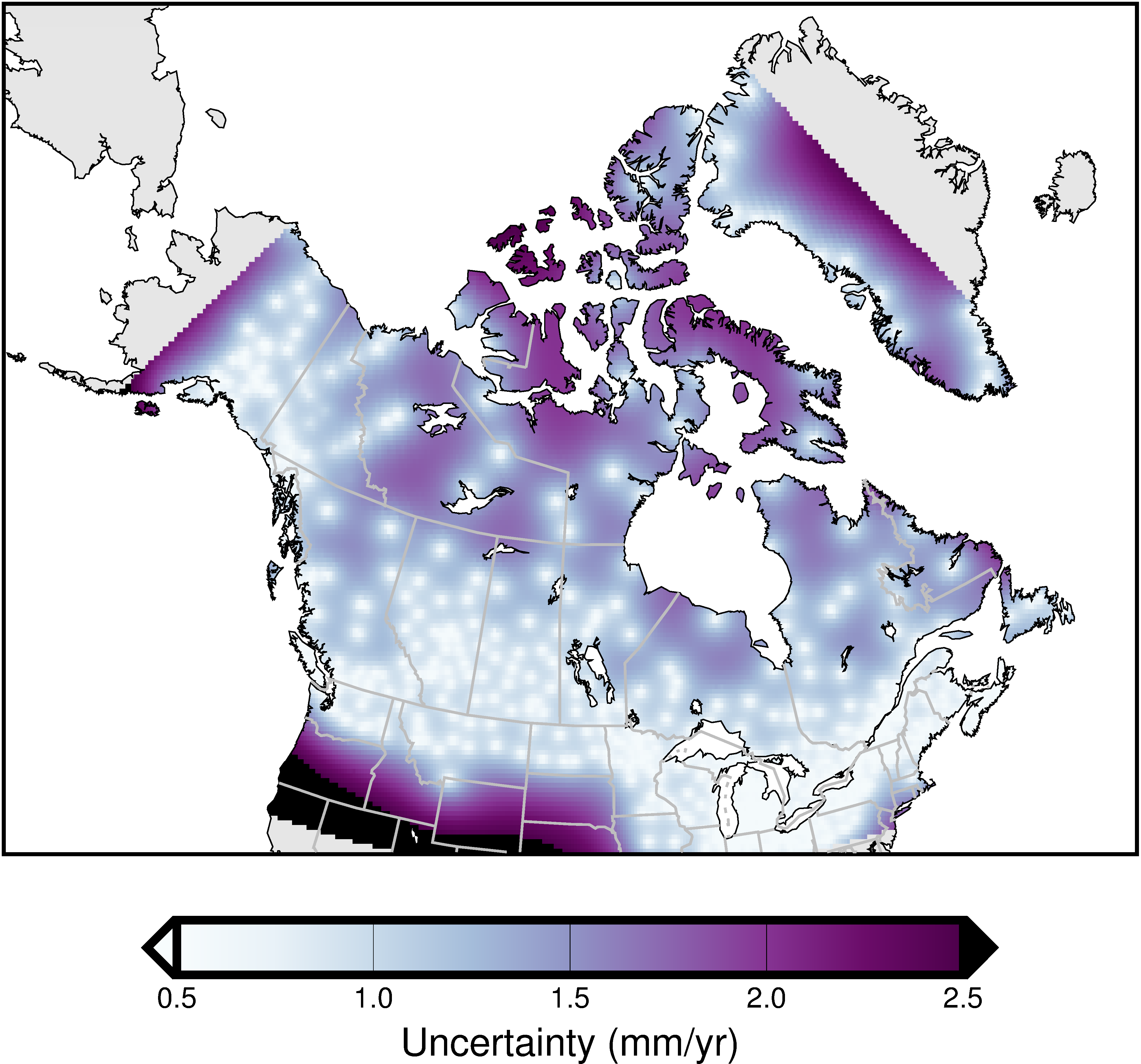
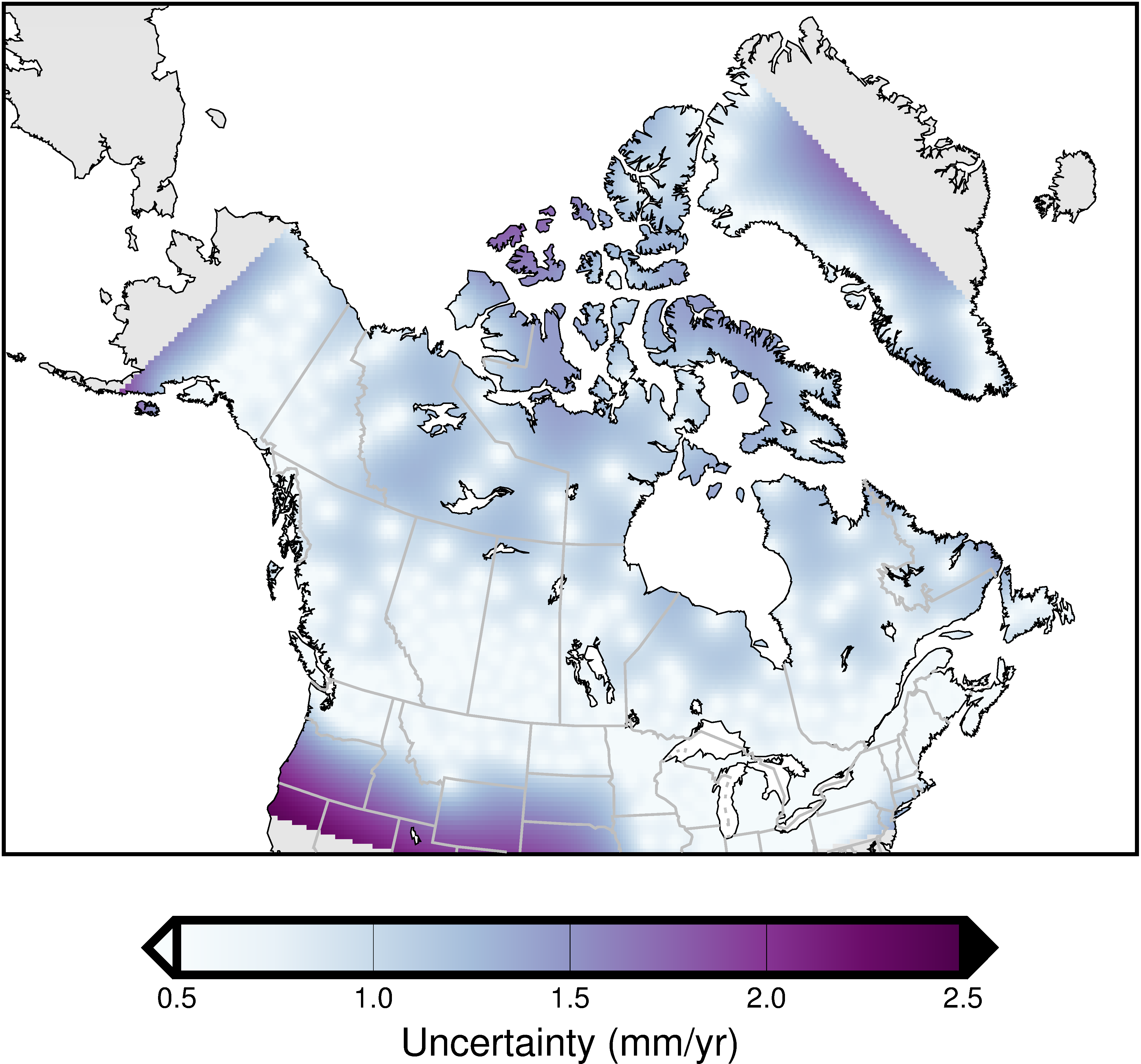
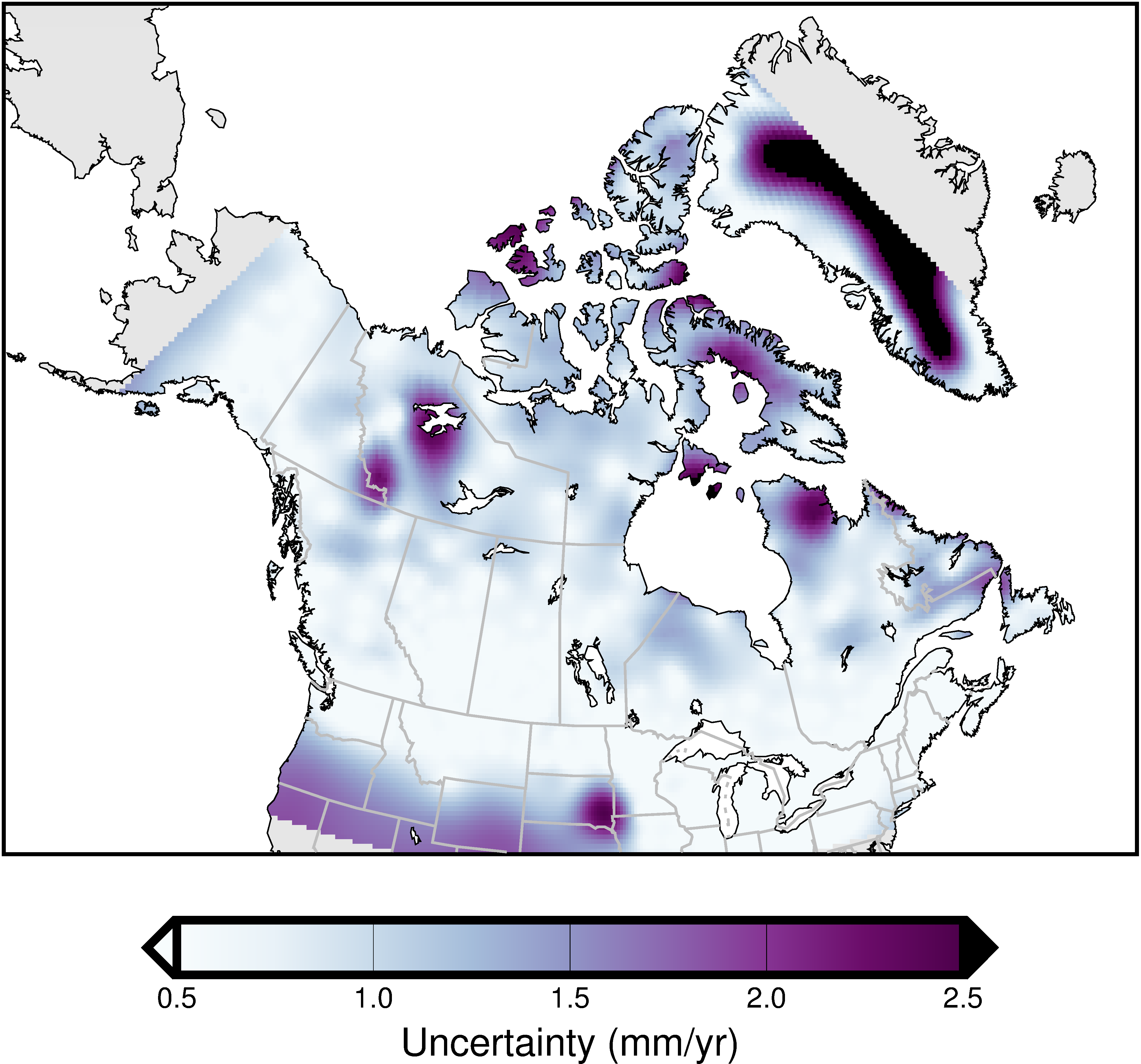
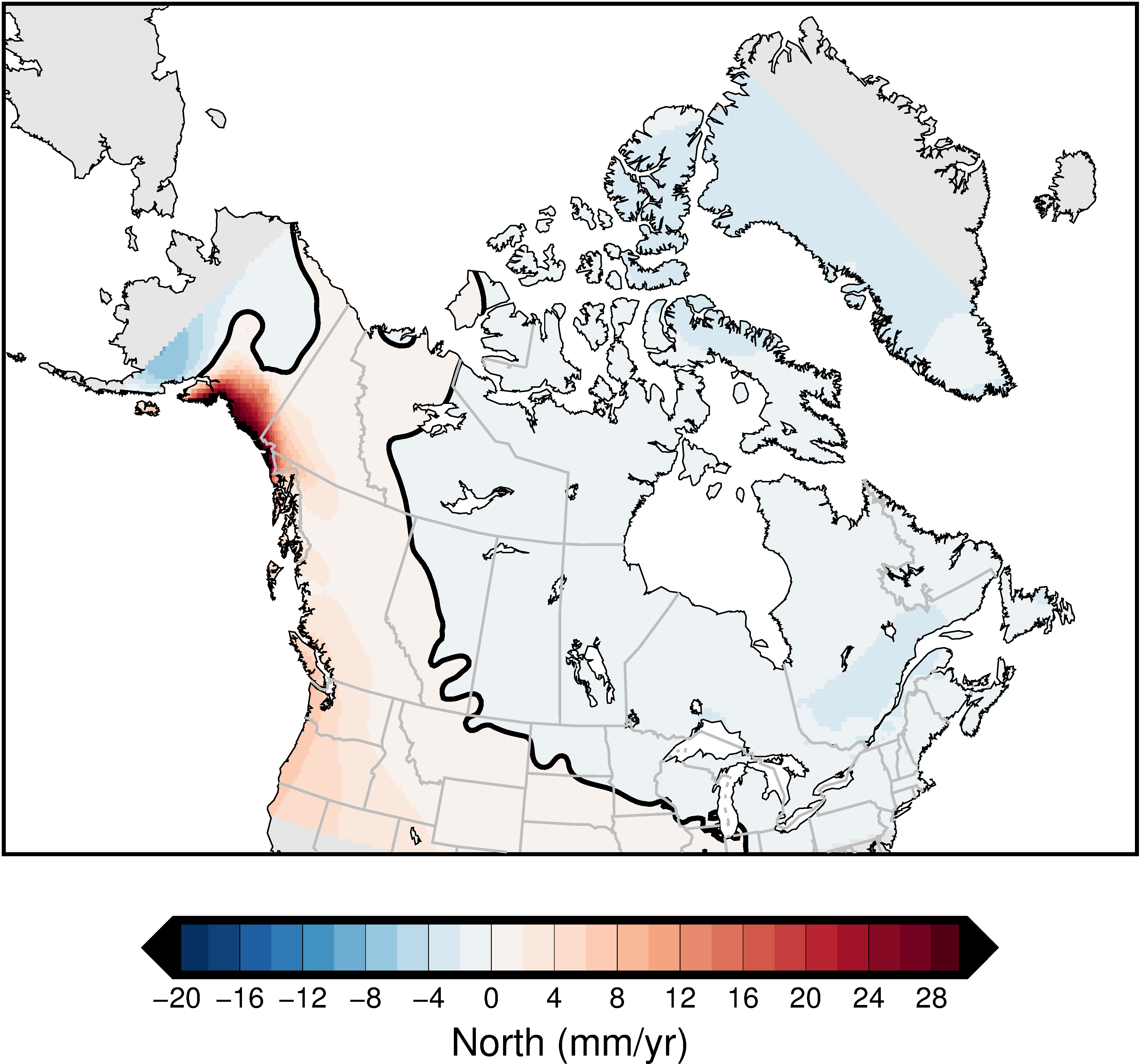
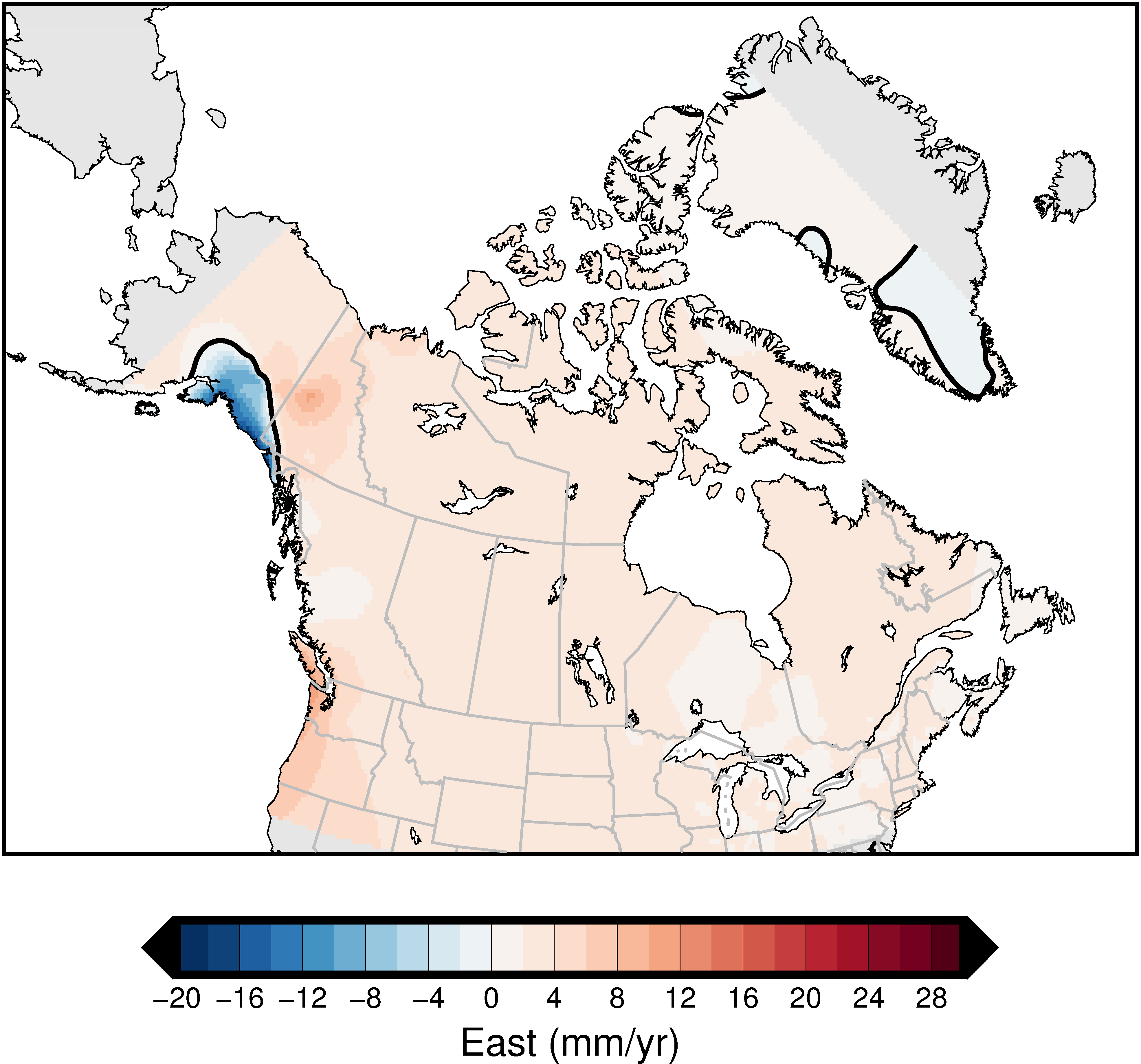
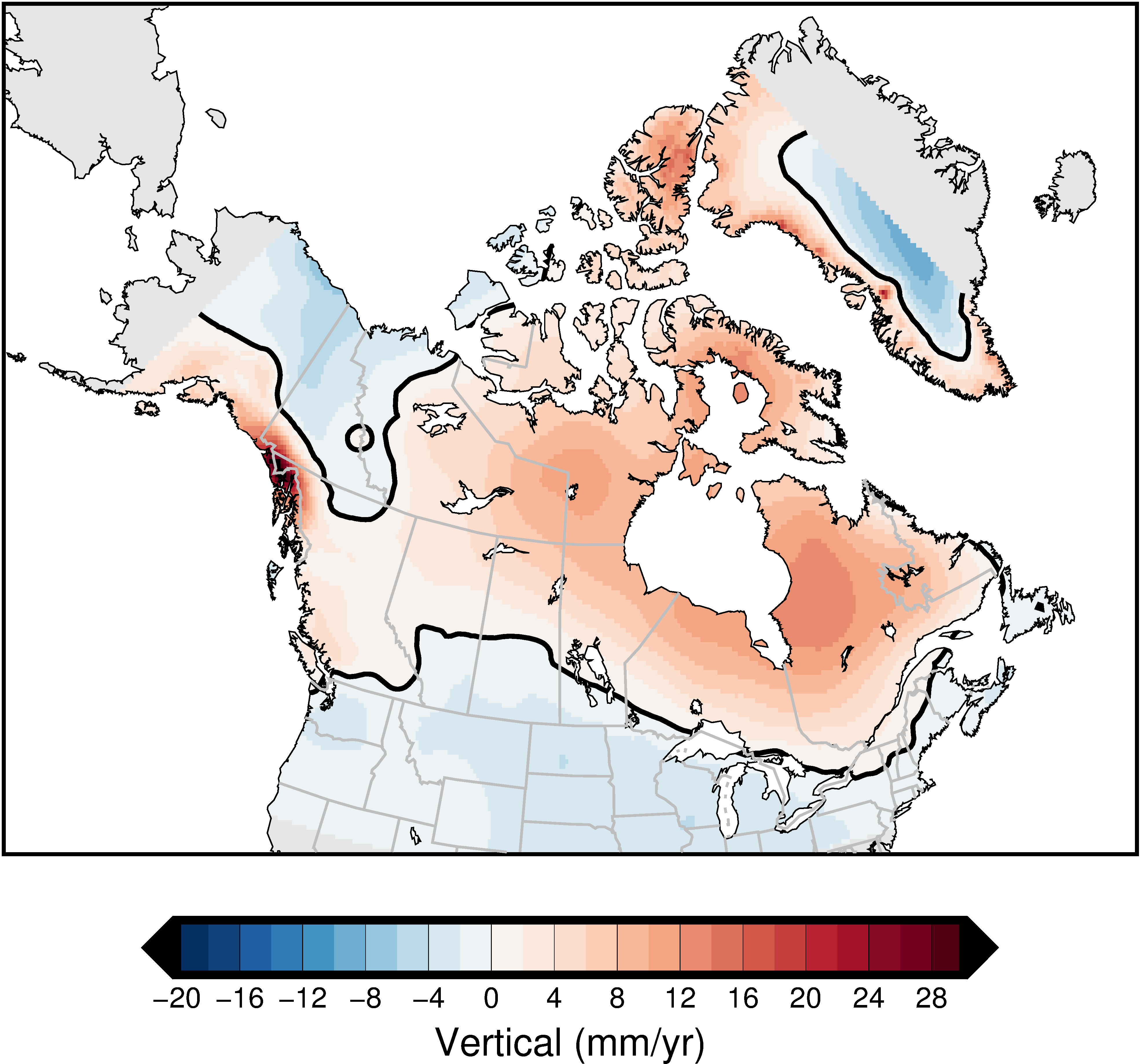
- updated gridded model of uncertainty estimates (see Figures 1a, 1b, and 1c).
What will be the impact on users?
- More accurate propagation of coordinates between epochs.
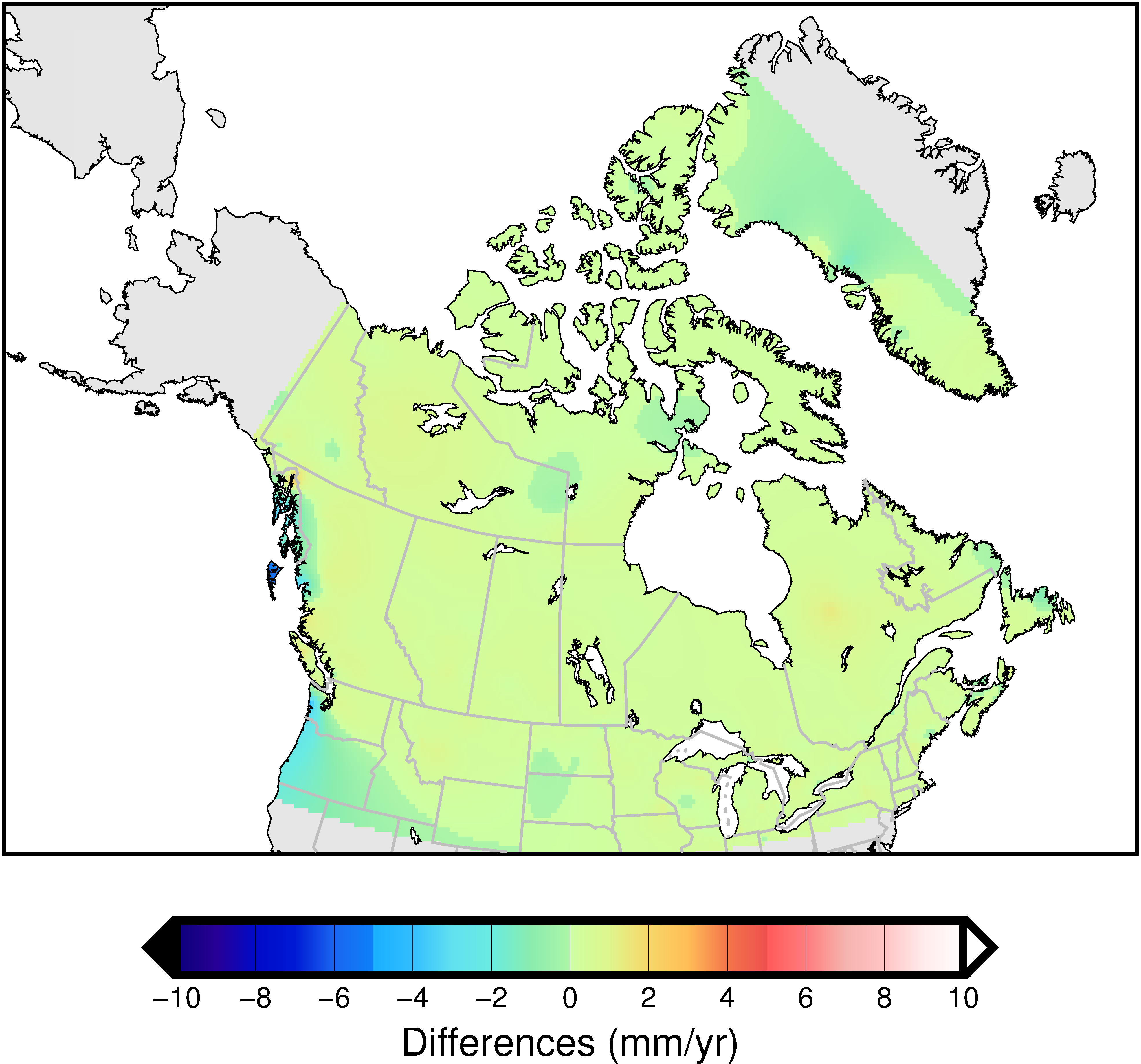
- Results of coordinate epoch propagation will differ when generated using different velocity grids. The magnitude of the difference between the grids varies by region. This will mostly affect users propagating over long periods (e.g. back to 2002.0 or 1997.0 reference epochs).
- The TRX desktop application provides users a choice of which model to use;
- Figures 2a, 2b, and 2c show the difference between the v8 and v7 velocity grids.
- Observed velocities may differ from those predicted by the velocity grid, especially where there are anomalous local motions such as post-seismic deformation or where the GNSS station distribution is sparse.


Download the NAD83(CSRS) v8.0 velocity grid - NAD83v80VG (see Figures 3a, 3b, and 3c)
For general information on how the national crustal velocity model for Canada is estimated, as well as specific information for the v7 model (NAD83v70VG), download the publication:
NAD83v70VG: a new national crustal velocity model for Canada
Along with the March 2019 release of the NAD83(CSRS) v7 velocity grid, CGS is releasing versions of the HTv2.0 hybrid geoid model for reference epochs 2002.0 and 2010.0. HTv2.0 is a hybrid geoid model allowing for the direct transformation of ellipsoidal heights in the NAD83(CSRS) reference frame to orthometric heights that are compatible with the Canadian Geodetic Vertical Datum of 1928 (CGVD28). HTv2.0 is based on the gravimetric geoid model CGG2000 and includes 1926 GPS constraints on benchmarks whose ellipsoidal heights are in NAD83(CSRS) at epoch 1997.0.
Why are new HTv2.0 models needed for epochs 2002.0 and 2010.0?
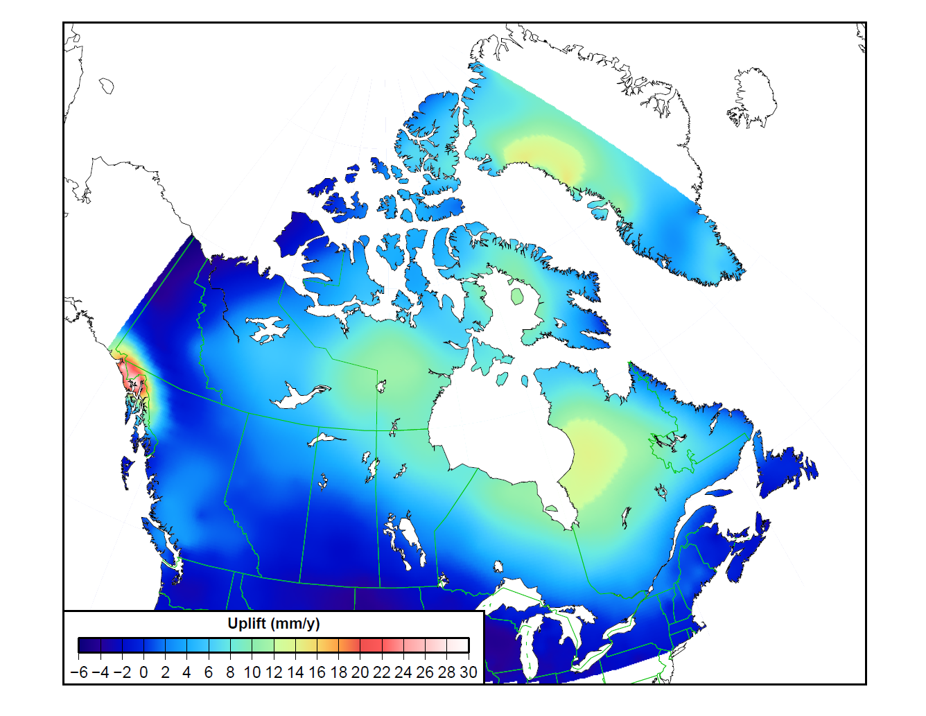
Most Canadian provinces and territories have updated their adopted NAD83(CSRS) reference epoch from 1997.0 to either 2002.0 or 2010.0 for their coordinates: latitude, longitude, ellipsoidal height (h), and orthometric height (H). These new reference epochs — having either 5- or 13-year spans from the previous reference epoch of 1997.0 — can represent height differences ranging from just a few mm in some regions to tens of cm in other regions (see figure 3 for a map of the vertical velocities in Canada). Thus, the use of HTv2.0 with ellipsoidal heights at epoch 2010.0 may calculate CGVD28 heights that are significantly different from the published values in some regions. This is because the published heights in CGVD28 are static (epochless) while published NAD83(CSRS) ellipsoidal heights are dynamic (change as the terrain moves up or down).
Even though CGS formally replaced CGVD28 with CGVD2013 in November 2013 and the provincial geodetic agencies adopted this new height system, there is still a need to provide a Height Transformation at epochs 2002.0 and 2010.0 in order to assure a smooth transition towards CGVD2013 for our clients.
How can users access CGVD28 with ellipsoidal or CGVD2013 heights in epochs 2002.0 and 2010.0?
- The CGS tool GPS·H now includes HTv2.0 models for each of the adopted NAD83(CSRS) epochs (1997.0, 2002.0, 2010.0). The filenames are as follows (where v70 represents the velocity grid used):
- HT2_1997.byn (simply a rename of HT2_0.byn);
- HT2_2002v70.byn;
- HT2_2010v70.byn.
- GPS·H also includes conversion grids for transforming between CGVD28 and CGVD2013 at each of the adopted CGVD2013 epochs. These filenames are as follows:
- HT2_1997_CGG2013a.byn (simply a rename of HT2_0_CGG2013a.byn);
- HT2_2002v70_CGG2013a.byn;
- HT2_2010v70_CGG2013a.byn.
- HTv2.0 versions (for epochs 1997.0, 2002.0, 2010.0) are available for download from the CGS Geoid Models page.
- The desktop version of GPS·H now comes with the HTv2.0 hybrid geoid models for the adopted epochs as well as the CGVD28 to CGVD2013 conversion grids.
- Users of CSRS-PPP who request CGVD28 heights will automatically have the NAD83(CSRS) v7 velocity grid applied to their ellipsoidal heights if they are not already in epoch 1997.0.
Beginning on 6 September 2023, both the web and desktop versions of GPS·H will support geoid height velocities (VN) for the first time. The Canadian Geodetic Survey (CGS) defines the Canadian Geodetic Vertical Datum of 2013 (CGVD2013) as a static reference surface, which means that the temporal motion of the geoid due to mass redistribution is neglected. However, an additional source of VN stems from the relative movement between reference frames. If a set of coordinates is not in the static reference frame of the geoid model (e.g., NAD83(CSRS) for CGG2013a) and the epoch of these coordinates is not at the reference epoch of the geoid model (e.g., 2011 for CGG2013a), then the geoid height will have an apparent velocity due to the time-dependent vertical transformation — or drift — between the frame of the coordinates and the frame of the geoid model. This vertical frame drift is now represented as a geoid height velocity and applied to correct the geoid height.
What does this mean for users of GPS·H?
As an example, if we take geoid model CGG2013a in the NAD83(CSRS) realisation having 2011.0 as the epoch of reference, the geoid height at one location will have the same value for any epoch because the geoid is considered static in this geometric reference frame. However, this same geoid model in an ITRF reference frame will have different geoid heights at different epochs at the same location caused by the drift between NAD83(CSRS) and ITRF.
Why is CGS now taking into consideration the geoid velocity?
The time-dependent transformation between NAD83(CSRS) and ITRF is quite small and was therefore neglected in GPS·H prior to this date, mainly to simplify the adoption of CGVD2013. The vertical drift between NAD83(CSRS) and ITRF varies between versions of ITRF, and for different locations in Canada, but in general is less than 2 mm/year. Although the vertical drift between NAD83(CSRS) and ITRF is small, it becomes more significant as we move further away from the CGG2013a reference epoch of 2011.
What if I work in CGVD2013 in the NAD83(CSRS) frame?
As mentioned, this geoid velocity is due to the vertical drift between reference frames, so NAD83(CSRS) users will not be impacted by this change.
What if I am working in CGVD28?
Since CGS only supports the HTv2.0 hybrid geoid models in the NAD83(CSRS) reference frame, CGVD28 users will also not be impacted by this change.
How can I determine the static reference frame of my geoid model?
CGS decided to consider Canadian geoid models (e.g., CGG2013a) static in NAD83(CSRS) while global geoid models (e.g., EGM2008) are considered static in their original 3-D geometric reference frame (e.g., ITRF2000).
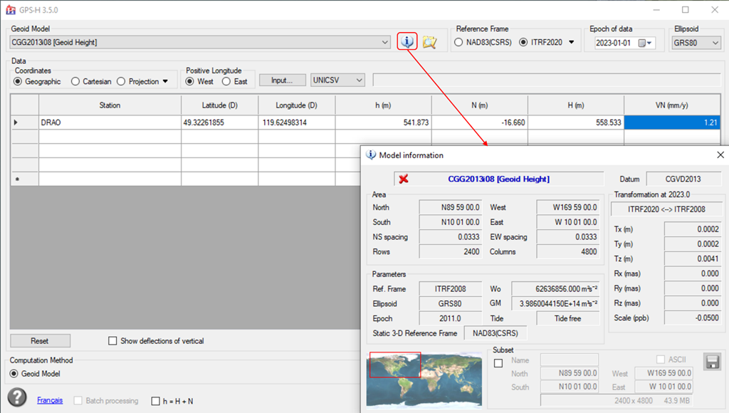
CGS also updated the header of their BYN format geoid models to indicate the static frame. These models with updated headers are available for download from the CGS Geoid Models page. The BYN header information can be viewed using the desktop version of GPS·H (see Figure 4).
What will happen when the U.S. adopts NAPGD2022?
In 2025, the U.S. will adopt a new height reference system to replace the North American Vertical Datum of 1988 (NAVD 88). The new system is called the North American-Pacific Geopotential Datum of 2022 (NAPGD2022). It has the same definition as CGVD2013, but it takes into consideration the temporal motion of the geoid. This means that the geoid heights at two different epochs for the same location will not have the same values.
In parallel with the U.S. adoption of NAPGD2022, CGS plans to update the current realization of CGVD2013 using a new common North American geoid model called GEOID2022. GEOID2022 is being developed in collaboration with the U.S., who plans to adopt both the static and dynamic components (sGEOID2022, and dGEOID2022). For Canada, CGS plans to continue defining CGVD2013 as a static datum initially, adopting only the static component (sGEOID2022), while providing the dynamic component (dGEOID2022) for scientific applications.
Use of Canadian Geodetic Survey products and data is subject to the Open Government Licence - Canada
- Date modified: